11 December 2010

Shoreline Erosion at York Shore Battery

While out walking earlier a few weeks ago we walked around the perimeter fence at York Shore Battery, below York Redoubt, to check things out. I hadn't been to the World War II era anti-submarine station in several months.

Not surprisingly, very little has changed at York Shore Battery since my previous visit. We did, however, notice that the erosion of the shoreline below the battery is rapidly deteriorating. Much of the reinforcements have failed.

The missing soil makes accessing the three adjacent light emplacements difficult and we didn't attempt it. You'll need to travel through the brush over unstable earth to make the trip.

York Shore Battery itself is not yet in danger of falling into the harbour. That shouldn't happen. However, the foundation of at least one of the light emplacements is being washed out on a regular basis. There will come a day when it, or they, will topple, depending on how well they're anchored to the hillside.

Photobucket


View York Redoubt in a larger map

11 October 2010

Stabilizing Fort McNab

As part of the federal government's economic action plan $1 025 000 (actionplan.gc.ca) was earmarked for the "stabilization of selected historic assets within the Fort McNab." Fort McNab was and is falling to pieces and many parts of the cannot be considered safe for unguided public access. The result of the stabilization should provide safe unguided public access to the fort. The work began during in September 2010. I became aware when Friends of McNabs announced via Twitter (Friends of McNabs @Twitter) that the fort would be upgraded, getting a "$1.6 million facelift," and would be closed to the public for the remainder of the year.

It was my assumption that major aspects of the fort's stabilization would include repairs to the crumbling building facades and the limiting of access to areas determined to be unsafe. Most of the access to underground areas was sealed years ago, I assume the remaining tunnels will be closed off as part of efforts to stabilize the fort.

When I visited Fort McNab with a group of close friends late in September 2010 work was already underway. My assumption that work would be done on crumbling building exteriors was confirmed by scaffolding. We were all pleasantly surprised to see much of the brush and overgrowth cut back revealing all kinds of new views.


We had a great time on the island again this year. Every time we visit we find something new or previously overlooked. I still haven't figured out an effective way to carry all of my gear and I have yet to learn how much water is enough. Apparently I need more than three litres for a twenty-four hour stay. We spent the night in tents after hiking through the interior, to McNabs Pond Trail to Strawberry Battery and back out through the Cliff Trail.

Taylor Made Tours (Capt. Steve Taylor, 902-448-4982/902-465-6272, Fisherman's Cove, Eastern Passage) ferried us to and from the island.


See also:

30 June 2010

HMS Liverpool and HMS Sutherland

Photos from Royal Navy guided missile destroyer HMS Liverpool and frigate HMS Sutherland at the Tall Ships Quay in Halifax during International Fleet Review public tours.

1. HMS Sutherland (left) and HMS Liverpool (Right).
Photobucket

2. Royal Navy helicopter art.
Photobucket

3. Royal Navy helicopter artillery.
Photobucket

4. HMS Sutherland's 'Merlin' helicopter.
Photobucket

5.
Photobucket

6. American guided missile cruiser USS Gettysburg and frigate USS Robert G. Bradley.
Photobucket

7. Sea Dart surface-to-air missiles aboard HMS Liverpool.
Photobucket

8. Sea Dart surface-to-air missile.
Photobucket

9. Anti-submarine torpedo.
Photobucket

29 June 2010

Halifax International Fleet Review - Helicopter Fly-By

Tuesday, June 29, 4:45pm at Purdy's Wharf, Halifax.

28 June 2010

Halifax International Fleet Review - QEII Motorcade

Monday, June 28, 4:15pm. Cogswell Street at North Park Street.

25 June 2010

Halifax International Fleet Review Arrivals - HMCS Toronto

I've been following as much of the Halifax International Fleet Review (IRF) as I possibly can.

Ships are now arriving regularly. Many of them will be open for public tours beginning as soon as tomorrow at 10am.

At approximately the same time this morning the Canadian frigate HMCS Toronto came into port and moored at the Nova Scotia Power redevelopment. Like all the other IFR ships to come to port this week, HMCS Toronto was escorted into the harbour by half a dozen small crafts. The boat closest to me was occupied by two sailors - the pilot carried only a sidearm, the other an assault rifle.

Prior to the Toronto's arrival the Glen-class naval tugs were busy installing a temporary dock for the frigate.

HMCS Toronto is moored just south of two American ships, the USS Robert G. Bradley, a general purpose escort vessel and USS Gettysburg, a guided-missile cruiser.

At the Maritime Museum of the Atlantic the Canadian Navy's flag-ship HMCS Athabascan is awkwardly moored in front of HMCS Sackville, the last remaining corvette, and CSS Acadia, a refitted science vessel that served in both world wars.

Some photos from this morning's walk.

1. HMCS Toronto
Photobucket

2. HMCS Toronto
Photobucket

3. HMCS Toronto successfully moored.
Photobucket

4. HMCS Athabascan (and just a bit of CSS Acadia)
Photobucket

5. USS Robert G. Bradley and USS Gettysburg
Photobucket

6. CFAV Glenside
Photobucket

19 June 2010

Update: Purcell's Cove Foundation

It turns out that the foundation in Purcell's Cove I wrote about on May 28 was a military installation as suspected.

Built in 1942 this foundation was once the 18th Anti-Aircraft Battery.

1.
Photobucket

2.
Photobucket

17 June 2010

Theodore, Silva and MS Maasdam

While Theodore Too departed the harbour tall ship Silva arrived at the Nova Scotia Power redevelopment to meet passengers who arrived last night on the cruise ship MS Massdam.

Photobucket

14 June 2010

Navy Vessels Leaving Port

Kingston-class Canadian Navy coastal defence vessel HMCS Moncton left port today just minutes after USS Boone, an American Perry-class guided missile frigate, departed at about 11am this morning.

USS Boone was in port with several other NATO ships and was one of the last to depart. Both vessels departed with small craft escorts.

1. HMCS Moncton
Photobucket

2. USS Boone
Photobucket

Link: CBC News: Major Naval Tests Planned for NB, NS

13 June 2010

South Shore Trip

We traveled about 100km on Highway 103 to Bridgewater where we followed Nova Scotia's Lighthouse Route, Highway 331, to the ocean. Along the way we ventured back several unmarked back roads. We knew the road would lead us to the ocean or a gravel pit depending on the side of the road we picked.

After forty-five minutes of gravel pits we chose an ocean drive. The drive through the brush to the ocean was tedious at times but was easily accomplished in the Rav 4. The road ended at an intersection with an old trail called Bear Trap Road. The Bear Trap has not been maintained in many years and large portions of it have been reclaimed by the beach. It is nearly impassible.

At the Bear Trap Road we happened upon two significantly damaged cabins. Destruction can be attributed to major storms including 2003's Hurricane Juan, as well as significant damage done by vandals.

We weren't able to drive any distance on the Bear Trap Road so we turned back toward the 331. Shortly after returning to civilization we experienced car trouble resulting in the procurement of a new battery in nearby West Dublin.

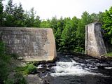
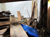
On the return trip to Halifax we stopped at a former hydro electric power plant that has been dormant for decades. We discovered a hole in the front of the building large enough to poke our heads in. I was able to snap a few quick pictures of the interior for the first time.

As expected, the power plant is largely filled with stored lumber.

1. Bear Trap Road
Photobucket

2. Small Cabin - Exterior
Photobucket

3. Small Cabin - Interior
Photobucket

4. Large Cabin - Exterior
Photobucket

5. The former contents of the large cabin found outdoors.
Photobucket

6. Large Cabin - Interior
Photobucket

7. Hydro Electric Power Plant
Photobucket

8. No longer in operation, water now flows freely.
Photobucket

9. Lumber stored inside the power plant.
Photobucket

10. Looking up inside the power plant.
Photobucket

NS Power redevelopment, Seaport Farmers' Market + Boats!

Some brief updates on development (and redevelopment). The Nova Scotia Power (NSP) redevelopment of the former power station at Lower Water Street and Marginal Road remains on schedule for completion March 2011.

Next door to the NS Power construction is the new Halifax Seaport Farmers' Market, scheduled to open next month (July 2010).

Tall Ships.. Another tall ship is in port this week. The French schooner Rara-Avis is at the Maritime Museum of the Atlantic. Like the Roald Amundsen earlier this month, the vessel is protected by a security perimeter and twenty-four hour guard.

I would imagine they are doing periodical public tours of the boat.

Some photos from the June 9th:

1. NSP's redevelopment of the former Lower Water Street thermal power station.
Photobucket

2. Glass now being installed on side facing Georges Island.
Photobucket

3. Glass on the north side of the build has been installed for several months.
Photobucket

4. Construction of the new Halifax Seaport Farmers' Market is progressing.
Photobucket

5. Rara-Avis and CSS Acadia.
Photobucket

03 June 2010

Roald Amundsen

Brig Roald Amundsen is in port at Halifax this week near the Maritime Museum of the Atlantic.

The pier Roald Amundsen is moored to has been closed and is blocked by both temporary chain-link fence and two private security guards.

Roald Amundsen is here from Eckernförde, Germany on a scheduled stop before departing soon to central Canada, through the Great Lakes, to the United States and then back, first to Montreal and then Halifax by the end of September 2010.

1. Moored.
Photobucket

2. Guarded.
Photobucket


Link: Roald Amundsen

29 May 2010

PBS Oil Leak Widget

I just happened across this widget on the PBS News website when looking for an update on the BP oil spill in the Gulf of Mexico off the coast of northeastern United States.

I thought it did a good job demonstrating all of the different opinions on the actual amount of oil being leaked into the ocean. US Geological Survey shows the most conservative estimate at 500 000 litres per day while "experts" suggest the leak may be almost ten times worse, at nearly 4.5 million litres per day.


Link: PBS Newshour: Gulf Oil Spill Coverage

28 May 2010

Purcell's Cove Foundation

Near Purcell's Cove Road lies an odd foundation in the middle of the forest.

I know next to nothing about it.

My best guess is that it was built and utilized by our military but has been unoccupied, perhaps even totally abandoned since World War II, at the absolute latest. The area is entirely grown in however it is easy to tell where roads and clearings once existed. It has been growing unchecked for a very long time, at least sixty-five or more years in my opinion.

Unfortunately, I can't share this location's coordinates as its condition is pristine and I'd hate to see it vandalized because of something I wrote here.

1. On Approach.
Photobucket

2. Inside.
Photobucket

3. Nearby.
Photobucket

If you happen to know a thing or two about this structure and would like to share, I encourage you to contact me through this website or any of my links on the right.

25 May 2010

Ships in the Harbour

I noticed two large ships in the harbour while passing through the waterfront this week.

1. Dredger IT INTREPID.
Photobucket

2. Canadian Coast Guard SAR vessel EARL GREY.
Photobucket

23 May 2010

Urban Explorers: Into the Darkness

On Friday night I sat down with the two friends I explore with most often to watch a documentary on our hobby.

We all thoroughly enjoyed the film which followed urban explorers like ourselves into both some of the most disgusting places I've ever witnessed to one of the most spectacular urban exploration finds that I'm aware of... the world's largest rocket launcher, left behind deep within a hole in the Florida Everglades.

The film spends a considerable amount of time in Europe, both in Paris, France and parts of Scotland. It is during the film's Paris footage that explorers go through obscure parts of catacombs and in Scotland where a good friend of mine leads a partially successful expedition to a former asylum that is interrupted by a caretaker... and a police helicopter.

If you're at all interested in what I write about on this blog, you should really try to track down this film and watch it yourself!

Link: Official Website for Urban Explorers: Into the Darkness


Cover:
Photobucket


Trailer:

21 May 2010

Inside York Shore Battery

Yesterday while dog walking at York Redoubt we walked down to the York Shore Battery at the bottom of the cliff. The area remains closed and the roof remains very dangerous. Even though the area is fenced off, every time we've gone down there recently we've encounter others behind the enclosure.

The building with the failing roof has had it's door sealed preventing easy access. With the exception of this sealed door, all other rooms remain open.

While at York Shore Battery we noticed an watch tower filled with pigeons and observed a Canadian Coast Guard vessel leaving port. On the towers- If you're interested in climbing up there, it really isn't worth it. Broken glass, rocks and pigeon crap. All that and the roof it's situated on is failing.

Link: Canadian Coast Guard: Maritimes Region

1. The failing roof at York Shore Battery.
Photobucket

2. Watch tower.
Photobucket

3. Rusting ladder providing risky roof access.
Photobucket

4. Graffiti continues to pop up. Chain-link won't stop vandals.
Photobucket

5. Canadian Coast Guard vessel leaving port.
Photobucket

6. Pigeon Tower.
Photobucket

7. Keep Off: Structure Unsafe, Roof Might Collapse.
Photobucket

8. York Shore Battery
Photobucket


View York Redoubt in a larger map