
I just happened across this widget on the PBS News website when looking for an update on the BP oil spill in the Gulf of Mexico off the coast of northeastern United States.
I thought it did a good job demonstrating all of the different opinions on the actual amount of oil being leaked into the ocean. US Geological Survey shows the most conservative estimate at 500 000 litres per day while "experts" suggest the leak may be almost ten times worse, at nearly 4.5 million litres per day.
Link: PBS Newshour: Gulf Oil Spill Coverage
29 May 2010
28 May 2010
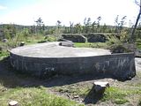
Purcell's Cove Foundation
Near Purcell's Cove Road lies an odd foundation in the middle of the forest.
I know next to nothing about it.
My best guess is that it was built and utilized by our military but has been unoccupied, perhaps even totally abandoned since World War II, at the absolute latest. The area is entirely grown in however it is easy to tell where roads and clearings once existed. It has been growing unchecked for a very long time, at least sixty-five or more years in my opinion.
Unfortunately, I can't share this location's coordinates as its condition is pristine and I'd hate to see it vandalized because of something I wrote here.
1. On Approach.

2. Inside.

3. Nearby.

If you happen to know a thing or two about this structure and would like to share, I encourage you to contact me through this website or any of my links on the right.
25 May 2010
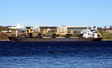
Ships in the Harbour
I noticed two large ships in the harbour while passing through the waterfront this week.
1. Dredger IT INTREPID.
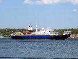
2. Canadian Coast Guard SAR vessel EARL GREY.

1. Dredger IT INTREPID.

2. Canadian Coast Guard SAR vessel EARL GREY.

23 May 2010
Urban Explorers: Into the Darkness
On Friday night I sat down with the two friends I explore with most often to watch a documentary on our hobby.
We all thoroughly enjoyed the film which followed urban explorers like ourselves into both some of the most disgusting places I've ever witnessed to one of the most spectacular urban exploration finds that I'm aware of... the world's largest rocket launcher, left behind deep within a hole in the Florida Everglades.
The film spends a considerable amount of time in Europe, both in Paris, France and parts of Scotland. It is during the film's Paris footage that explorers go through obscure parts of catacombs and in Scotland where a good friend of mine leads a partially successful expedition to a former asylum that is interrupted by a caretaker... and a police helicopter.
If you're at all interested in what I write about on this blog, you should really try to track down this film and watch it yourself!
Link: Official Website for Urban Explorers: Into the Darkness
Cover:

Trailer:
21 May 2010
Inside York Shore Battery
Yesterday while dog walking at York Redoubt we walked down to the York Shore Battery at the bottom of the cliff. The area remains closed and the roof remains very dangerous. Even though the area is fenced off, every time we've gone down there recently we've encounter others behind the enclosure.
The building with the failing roof has had it's door sealed preventing easy access. With the exception of this sealed door, all other rooms remain open.
While at York Shore Battery we noticed an watch tower filled with pigeons and observed a Canadian Coast Guard vessel leaving port. On the towers- If you're interested in climbing up there, it really isn't worth it. Broken glass, rocks and pigeon crap. All that and the roof it's situated on is failing.
Link: Canadian Coast Guard: Maritimes Region
1. The failing roof at York Shore Battery.
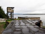
2. Watch tower.

3. Rusting ladder providing risky roof access.

4. Graffiti continues to pop up. Chain-link won't stop vandals.

5. Canadian Coast Guard vessel leaving port.

6. Pigeon Tower.

7. Keep Off: Structure Unsafe, Roof Might Collapse.

8. York Shore Battery

View York Redoubt in a larger map
16 May 2010
Through the Sally Port at York Redoubt
While at York Redoubt today we found the 'sally port' doors open allowing visitor access to a preserved part of the 200-year-old fortification that spends most of the year sealed off.
Like some of the other areas at York Redoubt that are closed to the public, the sally port is equipped with functioning lights.
The doors are closed daily at 6pm cutting off access from below to the upper parking lot and vice-versa.
1. Lower passageway.

2. Lower passageway.

3. Stairwell.

4. Upper passageway and stairwell.

5. York Redoubt's Artillery Store (built 1870).

View York Redoubt in a larger map
13 May 2010
Cambridge Battery at Point Pleasant Park
Earlier in the spring it was reported that crews were cutting back some of the brush at Cambridge Battery at Point Pleasant Park. This work was deemed necessary to prevent trees from falling on and doing damage to the fortifications at Cambridge Battery and nearby Fort Ogilvie.
This was my first trip through the US Civil War era battery since March 2007.
1. By the end of the 1860s the battery was fully manned complete with living accommodations.

2. All entrances are sealed, some more recently than others.
3. Much of Cambridge Battery is below ground and inaccessible.

4. Clearing of trees completed February 2010.

5. Sealed entrance to the battery.
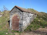
6. Cambridge Battery's guns were capable of defending both the harbour entrance as well as the Northwest Arm.

7. Mount for a 12 or 18-ton gun.
View Point Pleasant Park in a larger map
Link: Point Pleasant Park, Halifax, NS
This was my first trip through the US Civil War era battery since March 2007.
1. By the end of the 1860s the battery was fully manned complete with living accommodations.

2. All entrances are sealed, some more recently than others.

3. Much of Cambridge Battery is below ground and inaccessible.

4. Clearing of trees completed February 2010.

5. Sealed entrance to the battery.

6. Cambridge Battery's guns were capable of defending both the harbour entrance as well as the Northwest Arm.

7. Mount for a 12 or 18-ton gun.

View Point Pleasant Park in a larger map
Link: Point Pleasant Park, Halifax, NS
12 May 2010
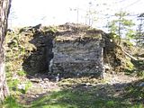
The Roof at Spion Kop (and York Shore Battery)
Earlier this evening I spent some time walking the paths at York Redoubt. While most paths lead to the harbour, or a steep cliff overlooking it. One of the last paths walked lead us to a well established party spot complete with a log-bench and well-used fire pit built of small stones.
We walked as far as Spion Kop and than back down through the unmarked footpaths to York Shore Battery. Along the way took interest in one of the concrete foundations. Like many of the other foundations around York Redoubt, the upper level has been removed leaving a sealed foundation. This particular foundation had a large hole permitting a good view of its interior. The ceiling has collapsed and the room is slowing being filled with scrap wood.
York Shore Battery remains closed to the public. It may only be a matter of time before some of the roofs collapse down into the battery. I don't recommend spending much, if any, time on the rooftops at York Shore Battery.
1. On the rooftop at Spion Kop.

2. Base Command Post from Spion Kop.

3. The path leading to Spion Kop.

4. Unknown foundation on road to York Shore Battery.

5. Inside the unknown foundation.

6. Just across the road from the unknown foundation is a second, larger, unknown foundation.
I believe this one is accessible through an open door.

7. Left to right: York Shore Battery's searchlight emplacements (Searchlights #690, #691 and #692), Georges Island, the community of Eastern Passage, and McNabs Island.

07 May 2010
Alice Oldendorff
Liberian cargo vessel 'Alice Oldendorff' idled in the harbour for the better part of today.
Link: MarineTraffic.com - Alice Oldendorff
Link: MarineTraffic.com - Alice Oldendorff

06 May 2010
Ships of Halifax Harbour - Part Two
When I was at the waterfront last week taking pictures (29 April 2010: Ships of Halifax Harbour - Part One) in the rain I managed to miss the real tugboats. The weather yesterday morning was great so I was again at the waterfront for my caffeine fix. I not only saw the tugs, but the regional police boat as well.
View Ships at Halifax Harbour in a larger map
1. 'Point Valiant'

2. 'Svitzer Bedford'

3. 'Point Chebucto'

4. 'Point Halifax' (Photo: 03/22/10)

5. Halifax Regional Police Patrol Boat

View Ships at Halifax Harbour in a larger map
1. 'Point Valiant'

2. 'Svitzer Bedford'

3. 'Point Chebucto'

4. 'Point Halifax' (Photo: 03/22/10)

5. Halifax Regional Police Patrol Boat

05 May 2010
Satellite Earth Station 2005
I first visited the satellite earth station while on Spring Break in 2005. I was really interested in the place and ended up leaving with hundreds of snapshots.
I've returned to the station annually since. Currently, the building sits open to the elements with a wrecking ball almost certainly in it's future. Anything of value has been removed from the site. I assume many components of a satellite earth station can be sold as scrap.
The massive dishes- In 2005, one dish stood upright while the other laid on its side. Since then, the standing dish has been cut, pulled down and mostly removed along with the other dish.
The whereabouts of my pictures from February 2005 were unknown for the longest time. I assumed I'd lost them before finding them on a burnt DVD destined for the shredder. I'd only had low resolution copies with an awful watermark to share until the discovery.
1. The first dish located at the station's main building.

2. Dish, again.

3. Inside the station below the dish.

4. Inside the station below the dish, looking up.

5. Again, computers inside the station.

6.

7. Manuals and guides for station operation.

8. More computers inside the station.

9. At the rear of the station is a garage and a number of derelict vehicles.

10.Inside the rear garage was a suspicious car complete with slashed tires and no windows.

11. The rear dish lying on it's side.

12. Close-up of the rear dish.

13. Entering the base of the rear dish is not recommended.

14. From the rear dish looking toward the front dish.

15. Leaving the facility, we walked through the long hallway and looked back at the first dish.

Subscribe to:
Posts (Atom)